NYC subway map from 1964

1964-nyc-subway-map-portion

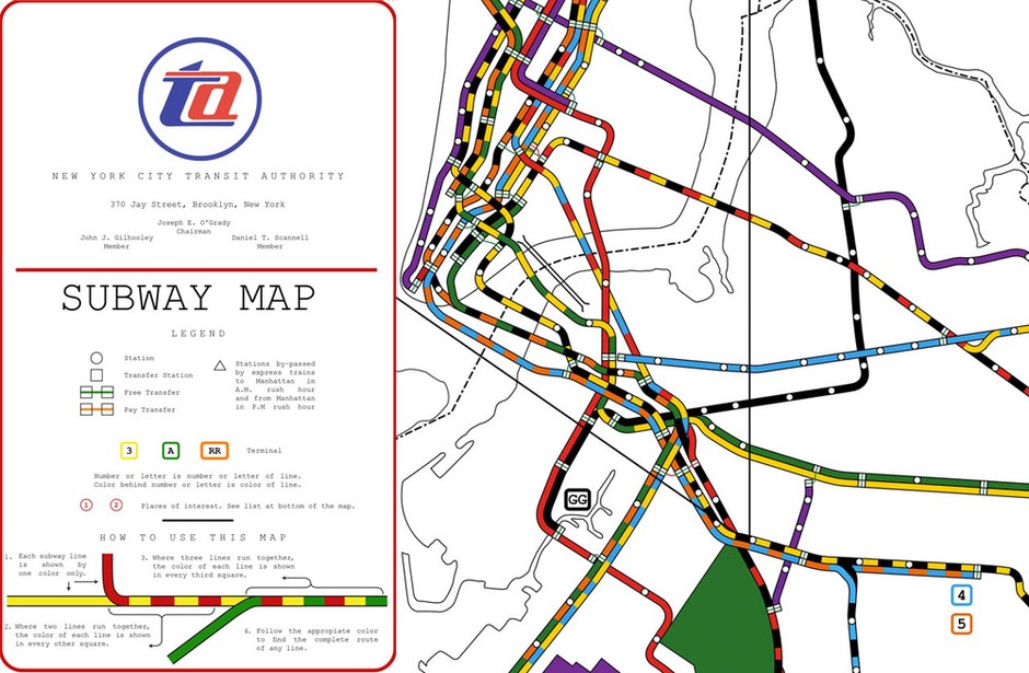
A version of the NYC subway map, which had been lost to history, was recently found and recreated digitally by Reka Komoli.

A local lawyer, R. Raleigh D’Adamo, was the winner of that 1964 contest. His design separated local from express routes and assigned separate colors to each of them. Submissions had to fit all the subway lines into a geographically correct map. So to use as little space as possible, D’Adamo employed colored squares along shared lines.

Personally, I would’ve found the map tough to use as a tourist, none of the station names are indicated. It was replaced by Massimo Vignelli’s version three years later.


Panoramic Map of New York

Panoramic Map of New York City, title section
Panoramic Map of New York City, midtown section

Map Cover: large | flickr
Map Front: small | large | flickr

Picked this map up a few months ago at a used bookstore, but kept forgetting to actually scan the thing. It’s pretty funky, with a weird perspective that you don’t usually see these days. The map has no date, but sometime around 1950 would be a decent estimate.

There’s a transit map on the back, but it needs some more work before it gets posted. We’ll save that project for a rainy day, I’ve already put far too much effort into stitching this one together.

Update

Comments also indicate that the map is likely from around the time of the 1939 World’s Fair. I’ve also added a copy of the transportation map on the back. Had scanned it in but forgot to stitch the images together.

Panoramic Map of New York City, Transportation map

Map Back: small | large | flickr

Update 2

From Jim Hughes at Codex 99.

Although the traditional maps were becoming more accurate, the ever-increasing height and sheer density of buildings made perspective mapping increasingly problematic. This map, prepared as a 1939 World’s Fair souvenir by Alexander Gross shows the limitations of traditional perspective.